
Nestled high in the Andes Mountains, Cusco stands as a captivating testament to Peru’s rich history and vibrant culture. Once the heart of the Inca Empire, this ancient capital invites travelers to explore its stunning blend of pre-Columbian marvels and colonial architecture. As you wander its cobblestone streets, you’ll discover a tapestry of traditions—from colorful festivals to mouthwatering cuisine—beckoning with irresistible charm. The majestic Sacsayhuamán fortress and the awe-inspiring Temple of the Sun are just the beginning of your journey through time. Cusco’s unique blend of old and new offers a genuine glimpse into Peru’s soul, where every corner holds stories of conquest, discovery, and cultural fusion. Join us as we unveil the wonders of Cusco, a city that not only echoes history but also vibrantly lives it, inviting you to be part of its ongoing narrative.
Cusco, often called the “navel of the world,” was more than just a city; it was the epicenter of the Inca Empire. This ancient civilization, which thrived from the early 15th century until the Spanish conquest in the 16th century, viewed Cusco as the spiritual and political heart of its vast domain. The city’s layout was designed to resemble a puma, a sacred animal symbolizing power and strength, which highlights the Incas’ deep connection with nature and their strategic urban planning.
The city’s significance in Incan civilization is evident in its meticulously constructed stone structures, many of which were built without the use of mortar. These architectural feats, such as the Qorikancha (Temple of the Sun), showcase the Incas’ advanced engineering skills and their profound reverence for their deities. Qorikancha, with its gold-plated walls and celestial alignments, served as a religious sanctuary dedicated to Inti, the Sun God, and was a focal point for worshiping the natural world.
Cusco’s role as the administrative and religious center of the Inca Empire also made it a cultural melting pot within the empire. The city’s population included not only native Incas but also people from conquered regions, who brought their own traditions and customs with them. This cultural amalgamation enriched Cusco’s social fabric, making it a vibrant and diverse metropolis. The legacy of this period remains palpable today, as many residents of Cusco proudly trace their heritage back to the Incas, preserving ancient customs and languages.
Even forgetting about Cusco City, the Cusco region is one of Peru’s most exciting areas. The lead attraction is Machu Picchu, but many visitors overlook the area’s lesser-known attractions. Many people spend at least three days near the city, and nearly everyone takes another two or three days to visit Machu Picchu and the other sites in the Sacred Valley. Still, many different villages and areas stimulate the energetic traveler with more than a week to spend. The Instituto Nacional de Cultura in Cusco has identified 36,000 known archaeological sites.

Chinchero, an old colonial settlement resting on Inca foundations overlooking the Sacred Valley and boasting a spectacular market, is only a forty-minute drive northwest of Cusco. To the northeast, towards the jungle, the attractive colonial-style village of Paucartambo, famous for its annual festival, nestles amid breathtakingly high Andean panoramas, close to Tres Cruces. In this remote mountain spot, locals and globetrotters witness a spectacular sunrise from the depths of the lowland Amazonia.
Cusco’s architectural landscape is a mesmerizing blend of Incan ingenuity and Spanish colonial influence, creating a unique fusion that captivates visitors. The city’s cobblestone streets are lined with centuries-old buildings that tell the story of its storied past. One of the most iconic examples is the Sacsayhuamán fortress, a monumental complex that showcases the Incas’ mastery of stonework. The massive stones, some weighing over 100 tons, were expertly fitted together without mortar, demonstrating the precision and skill of Incan engineers.
Another architectural marvel is the Qorikancha, also known as the Temple of the Sun, which was once the wealthiest temple in the Inca Empire. The Spanish conquerors, in awe of its grandeur, built the Santo Domingo Convent on its foundations, creating a striking juxtaposition of Incan and colonial architecture. Visitors can still see the original Incan walls, which survived earthquakes that toppled many colonial buildings. The site serves as a powerful reminder of Cusco’s layered history and the resilience of its people.
The historic center of Cusco, a UNESCO World Heritage site, is home to numerous other architectural gems. The Cusco Cathedral, with its ornate facade and intricate interior, is a testament to the artistic achievements of the colonial era. Built on the foundations of an Inca palace, the cathedral houses an impressive collection of colonial art, including the famous painting of the Last Supper, which features a guinea pig —a traditional Andean delicacy. The merging of Incan and Spanish elements in these structures provides a fascinating glimpse into the city’s complex past.
Cusco’s vibrant cultural heritage comes alive through its numerous festivals and traditions, celebrated with great fervor throughout the year. These events offer visitors a unique opportunity to experience the city’s rich cultural tapestry and connect with its people on a deeper level. One of the most important and widely celebrated festivals is Inti Raymi, also known as the Festival of the Sun, which is held every June. This ancient Incan ceremony pays homage to Inti, the Sun God, and marks the winter solstice, a time of renewal and gratitude.
Inti Raymi is a spectacular display of traditional costumes, music, and dance, featuring thousands of participants reenacting rituals that date back to the Inca Empire. The festivities begin at the Qorikancha and proceed to the Sacsayhuamán fortress, where the main ceremony is held. The event attracts both locals and tourists, creating a vibrant atmosphere that showcases the enduring legacy of Incan culture. Witnessing Inti Raymi is a truly immersive experience that transports visitors back in time.
Another significant celebration is the Feast of Corpus Christi, a Catholic festival infused with Andean traditions. This event, held 60 days after Easter, features elaborate processions with statues of saints and virgins carried through the streets of Cusco. The festivities are accompanied by traditional music, dance, and food, highlighting the syncretism between indigenous beliefs and Catholicism. The Feast of Corpus Christi is a vivid example of how Cusco’s cultural heritage has evolved over the centuries, blending elements from different eras and cultures.
Cusco’s culinary scene is a tantalizing journey through the flavors of the Andes, offering a mix of traditional dishes and modern interpretations that delight the palate. The city’s rich agricultural heritage, with its diverse range of ingredients, provides the foundation for its unique cuisine. One of the most iconic dishes is cuy, or guinea pig, which has been a staple in the Andean diet for centuries. This delicacy is often roasted or fried and served with potatoes and a spicy sauce, offering a taste of Cusco’s authentic culinary traditions.
Another must-try dish is lomo saltado, a fusion of Peruvian and Chinese flavors that reflects the country’s multicultural influences. This stir-fry of marinated beef, onions, tomatoes, and peppers, served with rice and potatoes, is a hearty and flavorful meal that showcases the creativity of Cusco’s chefs. The use of local ingredients, such as ají peppers and native potatoes, adds a distinctive touch to this popular dish.
Cusco’s vibrant food markets are a treasure trove of local produce and traditional snacks, providing a sensory feast for visitors. The San Pedro Market, in particular, is a bustling hub where you can sample a variety of Andean foods, from fresh fruits and vegetables to hearty soups and street food. Exploring the market is an adventure in itself, offering a glimpse into the daily lives of Cusco’s residents and the rich culinary traditions that continue to thrive in this historic city.
Cusco is a treasure trove of historical and cultural attractions, each offering a unique window into the city’s rich past. One of the most iconic sites is the Sacsayhuamán fortress, a testament to Incan engineering and architectural prowess. The massive stone walls, which were constructed without mortar, fit together with such precision that even a blade of grass cannot pass between them. The fortress offers breathtaking views of Cusco and serves as a venue for the annual Inti Raymi festival.
Another must-visit attraction is the Qorikancha, also known as the Temple of the Sun, which was once the most important temple in the Inca Empire. The Spanish built the Santo Domingo Convent on its foundations, creating a fascinating blend of Incan and colonial architecture. Visitors can explore the original Incan walls and learn about the temple’s significance in Incan religion and astronomy. The site also houses a museum with artifacts from both the Inca and colonial periods.
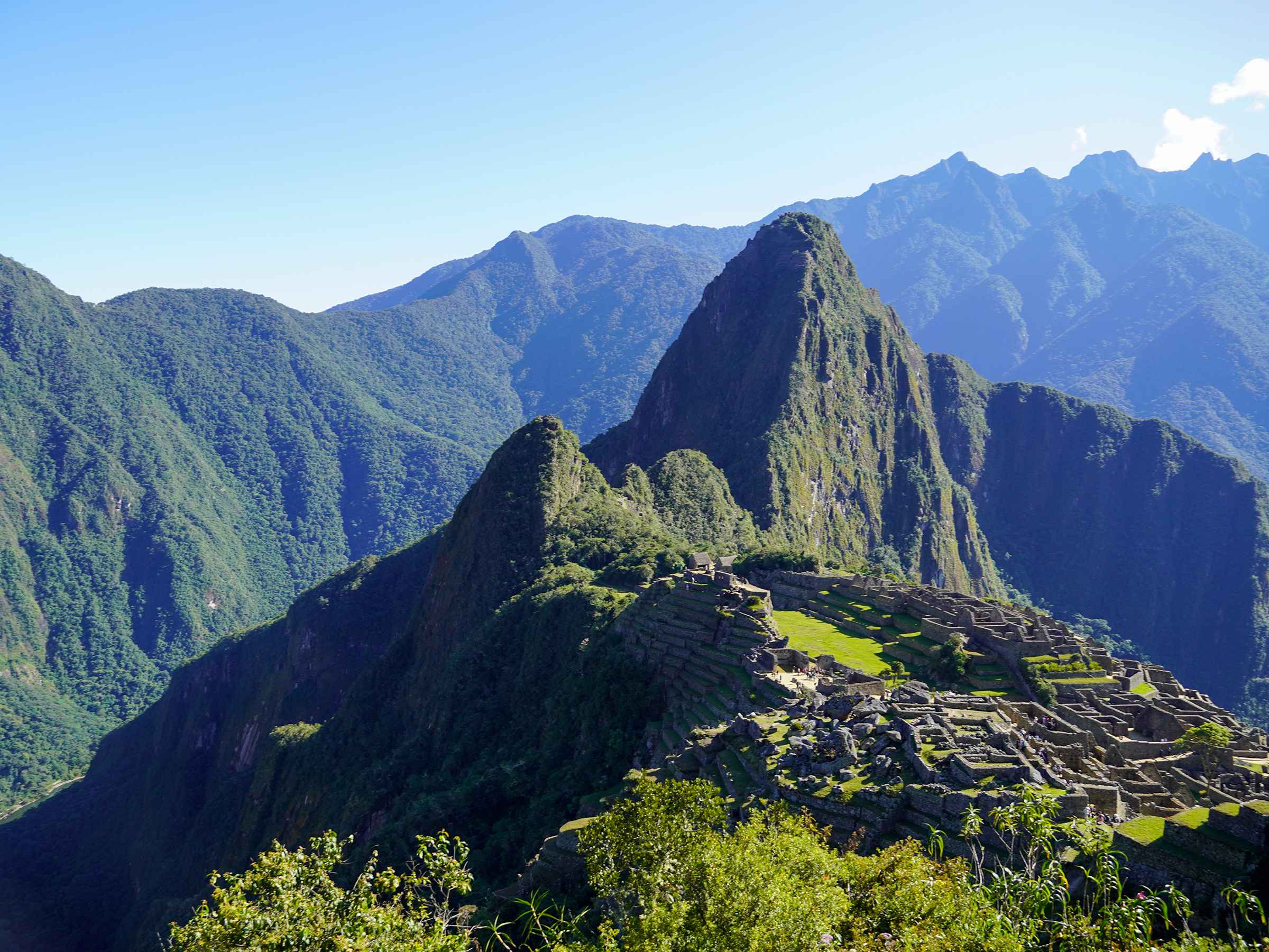
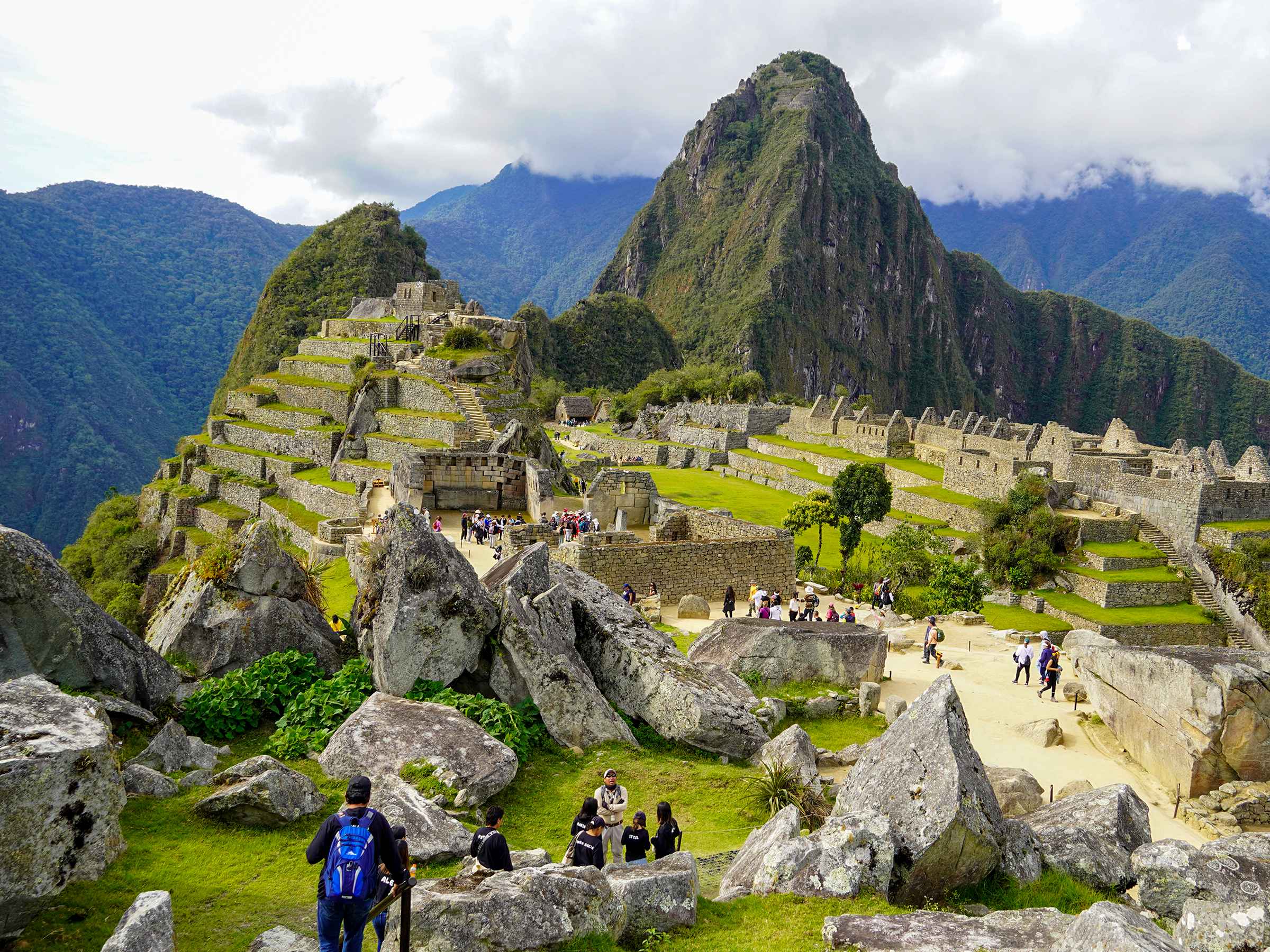
For those looking to explore beyond the city, the Sacred Valley of the Incas is a short drive from Cusco and offers a wealth of archaeological sites and stunning landscapes. The town of Ollantaytambo, with its well-preserved Incan terraces and fortress, provides a glimpse into the daily life of the Incas. The village of Pisac, known for its vibrant market and impressive ruins, is another highlight. The Sacred Valley is also the gateway to Machu Picchu, one of the most iconic archaeological sites in the world, making it an essential part of any visit to Cusco.
CHINCHERO (“Village of the Rainbow”) is 3762m above sea level, 28km northwest of Cusco, and off the main road. It overlooks the Sacred Valley, with the Vilcabamba range and the snowcapped peak of Salcantay dominating the western horizon.
The town is a small, rustic place where the local women, who crowd the central plaza during the market, still wear traditional dress. Primarily built of stone and adobe, the town blends seamlessly with the magnificent display of Inca architecture, ruins, megalithically carved rocks, and relics of Inca veneration of nature deities. The best time to visit is September 8 for the lively traditional fiesta. Failing that, the market, smaller but less touristy than Pisac’s, has good local craftwork.

The market (Sunday morning) is in the lower part of town, along with Calle Manco II. Uphill from here, along with the cobbled steps and streets, you’ll find a vast plaza, which may have been the original Inca marketplace.
It’s bounded on one side by an impressive wall, somewhat reminiscent of Sacsayhuaman’s ramparts, though not as massive. Constructed on three levels, some ten classical Inca trapezoidal niches can be seen along its surface. On the western perimeter of the plaza, the raised Inca stonework is dominated by a carved stone throne, near which are puma and monkey formations.
The plaza is also home to a superb colonial adobe Iglesia (daily 7 a.m.–5.30 p.m.; entry by Cusco Tourist Ticket, available here or in Cusco). It dates from the early seventeenth century. It was built atop an Inca temple or palace, possibly belonging to Emperor Tupac Yupanqui.
Who particularly favored Chinchero as an out-of-town resort—most of its aqueduct’s terraces, many of which are still in use today, were built at his command? The church itself boasts frescoes, murals, and paintings that, though decaying, remain very beautiful and evocative of its colonial past—many depicting the Cuzqueña school and celebrated local artist Mateo Cuihuanito. The most exciting depictions depict the forces led by local chief Pumacahua against the rebel Tupac Amaru II in the late eighteenth century.
The two prominent places to visit northeast of Cusco are Paucartambo, 112km from Cusco, and Tres Cruces, another 50km beyond Paucartambo.

The road between the two follows the Kosñipata Valley, whose name means “Valley of Smoke,” and then continues through cloudy, tropical mountain scenery to the Shintuya mission on the edge of Manu National Park. Legend has it that the Kosñipata enchants anyone who drinks its waters at Paucartambo, drawing them back repeatedly.
Eternally spring-like because of the combination of altitude and its proximity to tropical forest and guarding a significant entrance to the jungle zone of Manu, the pretty village of PAUCARTAMBO (“The Village of the Flowers”) is located some 110km from Cusco in a wild and remote Andean region. A silver-mining colony run by slave labor during the seventeenth and eighteenth centuries, it’s now a popular destination at its best in the dry season between May and September, particularly in mid-July when the annual Fiesta de la Virgen del Carmen takes place.

Visitors arrive in the thousands, transforming the village from a peaceful habitation into a considerable mass of frenzied, costumed dancers.
With its white buildings and traditional blue balconies, the beautiful central plaza features concrete monuments depicting a diverse range of characters who perform at the party, including demon-masked dancers, malaria victims, lawyers, tourists, and just about anything that captures the imagination of the local communities. Also on the plaza is the rather austere chapel, restored in 1998, which is splendidly simple yet full of large Cuzqueña paintings.
It’s also home to the sacred image of the Virgen del Carmen, which is unusual in its Indian (rather than European) appearance. When the pope visited Peru in the mid-1980s, the image was loaded onto a truck, driven to within 30 kilometers of Cusco, and then paraded on foot to the city center so the pope could bless it. Even if you don’t make it to Paucartambo for the festival, you can still see the ruined Chullpa burial towers at Machu Cruz, an hour’s walk from Paucartambo; ask in the village for directions. Travelers rarely visit here outside of festival time, unless en route to the rainforest by road.

Transportes Gallitos de las Roca’s buses depart from their Cusco office (Av. Diagonal Angamos 1952; T: 226895) daily to Paucartambo ($8.50; 3–4 hours) and three times a week to Pilcopata. Trucks, which leave from the end of Avenida Garcilaso, beyond the Ormeño office, are slightly cheaper but slower and far less comfortable.
Buses generally stop off in Paucartambo at the marketplace, from where you cross the stone bridge into the central part of town up to the plaza, where, during festival times only, there’s a tourist information office.
Paucartambo spends the first six months of every year gearing up for the Fiesta de la Virgen del Carmen. It’s an essentially female festival: tradition has it that a wealthy young woman, on her way to Paucartambo to trade a silver dish, found a beautiful (if body-less) head that spoke to her once she’d placed it on the plate.

The energetic, hypnotic festival lasts three or four days (usually July 16–19, but check with the tourist office in Cusco) and features crowds of locals in distinctive traditional costumes, as well as dancers and musicians, with market stalls and a slight fair springing up near the church. Clamoring down the streets are throngs of intricately costumed and masked dancers and musicians, the best-known of whom is the black-masked Capaq Negro, recalling the enslaved Africans who once worked the nearby silver mines.
Note the grotesque blue-eyed masks and outlandish costumes, a parody of the white man’s powers. Malaria, a post-conquest problem, tends to be a central theme.
An older adult suffers terrible agonies until a Western medic appears on the scene with the inevitable hypodermic in his hand. Suppose he manages to save the older man (a rare occurrence). In that case, it’s usually due to a dramatic muddying of prescriptions by his dancing assistants, and thus, Andean fate triumphs over science.
The natural special effects during sunrise at Tres Cruzes are, in their way, as magnificent a spectacle as the Fiesta de la Virgen del Carmen. At 3739m above sea level, on the last mountain ridge before the eastern edge of the Amazon Forest, the view is a marvel at any time: by day, it is a vast statement over the start of a massive cloud forest with all its weird vegetation; by night, it is an enormous star-studded jewel.
The sunrise is spectacular from the highest edge of the Manu Biosphere Reserve, particularly around the southern hemisphere’s winter solstice in June. It is multicolored, with multiple suns and incredible light, and lasts for hours. Transport to Tres Cruces can be a problem, except during the fiesta; however, on Monday, Wednesday, and Friday, Transportes Gallitos de las Rocas buses to Paucartambo continue to Pilcopata or Salvación; beyond Paucartambo, you can disembark at the Tres Cruces turnoff ($20; about 6 hours from Cusco).
However, be prepared to walk the remaining 14km into Tres Cruces, although you may be able to get a lift from a passing vehicle (especially early in the day, from late June to mid-July).
It takes about thirty hours to travel from Cusco to Lima via Abancay, Andahuaylas, and Ayacucho, then down to the Pisco Valley on the coast, just a few hours from Lima. Although only reducing the trip by around four hours, a more direct route goes to Abancay, then crosses the Andes to join the coast at Nazca (5–6 hours from Lima). If you take the Nazca route, there are a few opportunities to break the journey, for example, at Tampumayu (056/523490). A small Andean-style hotel village with individual houses of stone, adobe, and pan-tile roofs, a restaurant, and a bar, located about halfway between Puquio and Abancay at Km 361,
Whichever route you choose, you’ll pass through the village of Curahuasi. Within its district are a couple of diverting sights. By the community of Concacha, and some 3,500 m above sea level, is the archaeological complex of Sayhuite, comprising three massive, beautifully worked granite boulders.
The first 150km of road (and rail) south from Cusco towards Lake Titicaca passes through the beautiful valleys of Huatanay and Vilcanota, from where the legendary founders of the Inca Empire are said to have emerged.
A region outstanding for its natural beauty and rich in magnificent archaeological sites, it’s easily accessible from Cusco and offers endless possibilities for exploration or random wandering. The entire area is ideal for camping and trekking, but only the towns of Urcos and Sicuani provide reasonable accommodations.
Heading south from Cusco by road, after about 5km, you pass through the tiny pueblo of San Sebastián. Originally a small, separate village, it has become a city suburb.

Nevertheless, it has a tidy little church, ornamented with Baroque stonework, built on the site of a chapel erected by the Pizarros in memory of their victory over Almagro. The next place of interest is picturesque Oropesa, located approximately 25km away, which has traditionally been a town of bakers. This adobe church, boasting a uniquely attractive three-tiered belfry with cacti growing from it, is notable for its intricately carved pulpit and its beauty.
TIPON RUINS (daily 7 a.m.–5.30 p.m.; entry with the Cusco Tourist Ticket) is one of the most impressive Inca sites in terms of setting and architectural design. From Oropesa, the simplest way to reach the ruins is to backtrack down the main Cusco Road for 2km to a signposted track. Follow this up through a small village, once based around the now crumbling and deserted hacienda Quispicanchi, and continue along the gully straight ahead. Once on the path above the town, it’s about an hour’s climb to the first ruins.

Well hidden in a natural shelf high above the Huatanay Valley, the lower sector of the ruins is a stunning sight: a series of neat agricultural terraces watered by stone-lined channels, all astonishingly preserved and many still in use.
The impressive stone terracing evokes the Incas’ domination over a massive, subservient labor force, yet it’s little more than an elaborate attempt to increase crop yields.
At the back of the lower ruins, water flows from a stone-faced “mouth” around a spring—probably an aqueduct subterranean diverted from above. The entire complex is designed around this spring, which is reached by a path from the last terrace. Another sector of the ruins contains a reservoir and a temple block centered on a large, exploded volcanic rock—presumably a Huaca.
Although the temple’s stonework appears cruder than the agricultural terracing, its location remains beneficial. By contrast, the reservoir construction is sophisticated. It was initially built to hold 900 cubic meters of water, which gradually dispersed through stone channels to the Inca “farm” directly below.
A large tapering stone aqueduct from the back of the reservoir crosses a small gully before continuing uphill, about a thirty-minute walk, to a vast zone of unexcavated terraces and dwellings.
Beyond these, over the lip of the hill, you come to another level of the upper valley covered in Inca terracing homes and large stone storehouses.

These are the size of the lower ruins and are still used by locals who’ve built their own houses among them. The terracing at Tipon is so impressive that some archaeologists believe it was an Inca experimental agricultural center, much like Moray, and a citadel.
It’s a breathtaking place to camp, with no village or habitation in sight and fresh, running water. There’s a splendid stroll down the main road; take the path through the locals’ huts in the upper sector to the other side of the stream and follow it down the hillside opposite Tipon. This route offers an excellent perspective on the ruins and vistas towards Cusco, north, and over the Huatanay/Vilcanota valleys to the south.
About 7 kilometers south of Oropesa, the neighboring pre-Inca ruins of Pikillacta and Rumicolca are visible along the road. After passing the Paucartambo turnoff, near the ruins of an ancient storehouse and the small red-roofed pueblo of Huacarpay, the road climbs to a ledge overlooking a vast alluvial plain and Lucre Lake (now a weekend resort for Cusco’s workers). At this point, the route follows the margin of a stone wall that defended the pre-Inca settlement of Pikillacta.

Spread over an area of at least fifty hectares, PIKILLACTA, or “The Place of the Flea” (daily 7 a.m.–5.30 p.m.; entry by Cusco Tourist Ticket), was built by the Huari culture around 800 AD, before the rise of the Incas. Its unique, geometrically designed terraces surround a group of bulky two-story constructions; apparently, these were entered by ladders reaching up to doorways set well off the ground in the first story—very unusual in ancient Peru.
Many of the walls were built of small cut stones joined with mud mortar, and among the most exciting finds were several round turquoise statuettes. The city is in ruins, but it’s still evident what once occupied much of the site, in barracks-like quarters.
When the Incas arrived early in the fifteenth century, they modified the site to suit their purposes, possibly even building the aqueduct that once connected Pikillacta with the ruined gateway of Rumicolca, which straddles a narrow pass by the road, just a fifteen-minute walk further south.
This massive defensive passage, RUMICOLCA (open all day; free), was also initially constructed by the Huari people and served as the southern entrance to their empire’s frontier.
Later, it became an Inca checkpoint, regulating the flow of people and goods into the Cusco Valley; no one was permitted to enter or leave the valley via Rumicolca between sunset and sunrise. The Incas improved on the rather crude Huari stonework of the original gateway, using regular blocks of polished andesite from a local quarry. The gateway still stands, rearing twelve solid meters above the ground, and is one of the most impressive Inca constructions.
About halfway between Rumicolca and Urcos, the otherwise insignificant villages of Andahuaylillas and Huaro hide deceptively beautiful colonial churches. In the tranquil and well-preserved town of Andahuaylillas, the adobe-towered church sits above an attractive plaza, fronted by colonial houses, just ten minutes from the roadside restaurant where buses and minibusses drop off and pick up passengers. Built in the early seventeenth century on the site of an Inca temple, the church had an exterior balcony from which the priests would deliver sermons. While it’s a relatively small church with only one nave, it is a magnificent example of local colonial art. Huge Cuzqueña canvases decorate the upper walls. Below are some unusual murals, slightly faded over the centuries; the ceiling, painted with Spanish flower designs, contrasts strikingly with a tremendous Baroque altar.

The road leaves the Río Huatanay and enters the Vilcanota Valley to the south. HUARO, crouched at the foot of a steep bend in the road 3km from Andahuaylillas, has a much smaller church whose interior is covered with colorful murals of religious iconography, angels, and saints. The massive gold-leaf altarpiece dominates the entire place as you enter. Out in the fields beyond the village, as you climb towards Urcos, you can see boulders gathered together in mounds to clear the ground for the simple ox-pulled plows still used here.
Climbing over the hill from Huaro, the road descends to cruise past Lake Urcos before reaching the town, which shares the lake’s name. According to legend, the Inca Huascar threw his heavy gold chain into these waters after learning that strange bearded aliens—Pizar and his crew—had arrived in Peru. A simple chapel stands poised at the top of a small hillock between the lake and the town. If you find it open, visit several excellent Cuzqueña paintings.
The town of URCOS rests on the valley floor, surrounded by weirdly sculpted hills. It centers on the Plaza de Armas, where several substantial old trees give shade to Indians selling bread, soup, oranges, and vegetables. On one side of the plaza, particularly busy during the town’s excellent, traditional Sunday market, there’s a large, crumbling old church; on the other, there are low adobe buildings.
One of the unusually shaped hills surrounding Urcos is named after the creator, God Viracocha. He is said to have stood on its summit and ordered beings to emerge from the hill, thus creating the town’s first inhabitants. In tribute, an ornate Huaca with a gold bench was constructed to house a statue of the god. Here, the eighth Inca emperor received a divinatory vision in which Viracocha appeared to him, announcing that “great good fortune awaited him and his descendants.” The emperor adopted the imperial name Viracocha Inca, supposedly inspired by his first attempt to conquer non-Inca territory. However, his son, Pachacuteq, raised the empire to its most incredible heights.
Between Urcos and Sicuani, the road passes through San Pedro de Cacha, the nearest village (4 km) to the imposing ruins of the TEMPLO DE RAQCHI (daily 9 a.m.–5.30 p.m.; $8), built in honor of Viracocha, the Inca creator god. Buses pass within a few hundred meters of the temple entrance. The temple was built to appease the god Viracocha after he had caused the nearby volcano of Quimsa Chata to spew fiery boulders in a fit of rage, and even now, massive volcanic boulders and ancient lava flows scar the landscape as a constant reminder.

With its adobe walls over 12 meters high on polished stone foundations, the site is scattered with numerous other buildings and plazas, including barracks, cylindrical warehouses, a palace, and aqueducts. Raqchi was an important religious center. Today, the only ritual left is the annual Raqchi Festival (usually June 16–22), a dramatic, untouristy fiesta comprising three to four days of folkloric music and dance performed by groups congregating here from as far away as Bolivia to compete on the central stage.
The performances are well stage-managed, but the site can be mayhem in a boggy field, with hundreds of food stalls, a funfair, Quechua women selling chicha maize beer, and their drunken customers staggering through the tightly knit crowds.
Also accessed from the Urcos to Sicuani road, there’s the PUENTE COLGANTE, a hanging or suspension rope bridge that has been rebuilt almost ceremonially every year since before the Spanish conquest. Annually, up to a thousand locals gather on the second Sunday in June to rebuild the bridge using traditional techniques and materials, including ichu grasses, to make ropes for the 33-meter span.
The building and celebrations generally take three or four days, concluding with a ceremony and dancing between the area’s principal Ayllus or clans. To get to the Puente Colgante, you must get off a bus or combi at Combapata, about 30km before Sicuani and 10km further south than Checacupe. From Combapata, it’s another 31km (45 more by car) to the suspension bridge.
SICUANI, about 20km from Raqchi, is the capital of the province of Canchis and quite a thriving agricultural and market town, not entirely typical of the settlements in the Vilcanota Valley. Its busy Sunday market is renowned for cheap, excellent woolen artifacts, which you may also find on the train if you pass through Sicuani between Puno and Cusco.
Although not a particularly exciting place — too many tin roofs and an austere atmosphere — the people are friendly, making it an excellent base for trekking into snowcapped mountain terrain close to the vast Vilcanota mountain range, which separates the Titicaca Basin from the Cusco Valley.

Camping is the best way to see this part of Peru, but if you don’t have a tent, several hotels are in town, including the reasonably comfortable Hostal Tairo, C Mejia 120 (T351297). The train journey south continues towards Puno and Lake Titicaca. The Vilcanota Valley begins to close around the line as the tracks climb La Raya Pass (4300m) before dropping down into the desolate pampa that covers much of inland southern Peru.
Cusco is not only a cultural and historical hub but also a paradise for eco-tourism and adventure enthusiasts. The region’s diverse landscapes, ranging from lush valleys to rugged mountains, provide the perfect backdrop for a variety of outdoor activities. Trekking is one of the most popular pursuits, with the Inca Trail being the crown jewel. This iconic trek takes hikers through stunning Andean scenery, past ancient ruins, and culminates at the awe-inspiring Machu Picchu. The journey is as rewarding as the destination, offering a deep connection with nature and the region’s rich history.
For those seeking a more off-the-beaten-path experience, the Salkantay Trek offers an alternative route to Machu Picchu. This challenging trek takes adventurers through diverse ecosystems—from tropical forests to snow-capped peaks—offering breathtaking views and a sense of solitude. The trek passes through remote villages, allowing trekkers to interact with local communities and gain insight into their traditional way of life.
Cusco also offers a range of adrenaline-pumping activities, such as white-water rafting on the Urubamba River, mountain biking in the Sacred Valley, and paragliding over the Andean highlands. These activities provide a thrilling way to experience the region’s natural beauty and are sure to leave lasting memories. Eco-tourism in Cusco not only offers adventure but also promotes sustainable travel practices, ensuring that the region’s natural and cultural heritage is preserved for future generations.
Visiting Cusco requires some preparation to ensure a smooth and enjoyable trip. One of the most critical considerations is acclimatization to the high altitude, as Cusco sits at an elevation of 3,400 meters (11,200 feet) above sea level. It’s advisable to take it easy for the first few days and stay hydrated to minimize the risk of altitude sickness. Drinking coca tea, a traditional remedy, can also help alleviate symptoms such as headaches and dizziness.
When packing, it’s essential to bring layers, as the weather in Cusco can be unpredictable. Mornings and evenings can be chilly, while afternoons may be warm, especially if you’re engaging in outdoor activities. A good pair of walking shoes is also a must, as the city’s cobblestone streets and surrounding trails can be challenging to navigate without proper footwear. Additionally, don’t forget to bring sunscreen and a hat, as the high altitude intensifies the sun’s rays.
Cusco is a relatively safe city for travelers, but it’s always wise to take standard precautions. Keep an eye on your belongings, especially in crowded areas such as markets and festivals, and avoid walking alone at night in unfamiliar neighborhoods. It’s also a good idea to carry a copy of your passport and essential documents, leaving the originals in a secure location. By following these practical tips, you can ensure a safe and memorable visit to this enchanting city.
While tourism has brought economic benefits to Cusco, it has also had significant impacts on the local communities. The influx of visitors has created job opportunities in sectors such as hospitality, transportation, and handicrafts, contributing to the region’s economic growth. However, the rapid expansion of the tourism industry has also led to challenges, including rising living costs and strain on local resources and infrastructure.
One of the most pressing issues is the preservation of Cusco’s cultural and historical heritage. The high volume of tourists visiting sites like Machu Picchu and the Sacred Valley has raised concerns about environmental degradation and the potential damage to these priceless landmarks. Efforts are underway to implement sustainable tourism practices, such as limiting visitor numbers at specific sites and promoting eco-friendly travel options. These measures aim to balance the benefits of tourism with the need to protect Cusco’s cultural and natural treasures.
Tourism has also influenced the social fabric of local communities, bringing both opportunities and challenges. While many residents have embraced the economic benefits of tourism, it is also essential to ensure that the cultural integrity and traditions of the communities are respected and preserved. Initiatives that promote cultural exchange and responsible tourism can help foster mutual understanding and respect between visitors and locals, creating a more sustainable and enriching experience for all.
Cusco enchants visitors with its rich history, vibrant culture, and breathtaking landscapes. As the former heart of the Inca Empire, it offers a deep connection to Peru’s ancient past. At the same time, its colonial architecture and modern amenities create a dynamic and diverse urban experience. From the awe-inspiring ruins of Sacsayhuamán to the lively festivities of Inti Raymi, Cusco is a place where history comes alive and traditions are celebrated with pride.
The city’s culinary scene, blending traditional Andean flavors with contemporary innovations, offers a delicious exploration of Peru’s gastronomic heritage. Whether you’re savoring a plate of roasted cuy or sampling fresh produce at the San Pedro Market, Cusco’s cuisine is sure to leave a lasting impression. The surrounding landscapes, from the Sacred Valley to the high peaks of the Andes, offer endless opportunities for adventure and eco-tourism, allowing visitors to experience the region’s natural beauty firsthand.
Ultimately, Cusco’s enduring allure lies in its ability to seamlessly blend the old with the new, creating a unique and captivating destination that invites travelers to explore, learn, and connect. As you wander its ancient streets and immerse yourself in its vibrant culture, you’ll discover that Cusco is not just a city to be seen, but a place to be experienced and cherished. Its stories, traditions, and people will leave an indelible mark on your heart, making your journey to Cusco an unforgettable adventure.

Complete guide to visiting the last Inca rope bridge in Peru from Cusco. Planning to visit the Q’eswachaka…

Planning to attend Inti Raymi 2026 in Cusco? This complete travel guide covers everything you need to know…
Last-Minute Machu Picchu: How Travelers Still Visit Without Tickets from Cusco The Reality of Last-Minute Travel in Cusco…

Machu Picchu and Hiram Bingham’s Legacy: Rediscovery, Debate, and Historical Impact Machu Picchu continues to fascinate travelers, historians,…
Machu Picchu is not only one of the most iconic archaeological sites in the world — it is…

The terraces of Machu Picchu are one of the most impressive features of the site. Built into the…

Machu Picchu is one of the greatest examples of ancient engineering in the world. One of its most…

Machu Picchu is not only an archaeological wonder—it is also a deeply spiritual place. Surrounded by sacred mountains…
Aguas Calientes: The Gateway to Machu Picchu Aguas Calientes, also known as Machu Picchu Pueblo, is the main…

Peru Altitude Guide Peru is a land of breathtaking landscapes and rich cultural heritage. Its diverse geography includes…

Planning a Machu Picchu climb? There is more than one way to reach the citadel — from multi-day…

The Sacred Valley of Cusco is not just a stop on the way to Machu Picchu—it’s one of…