Tucked away in the rugged Andes, Choquequirao is a treasure that beckons adventurers seeking to experience the breathtaking beauty of Peru without the crowds. Often overshadowed by its more famous counterpart, Machu Picchu, this archaeological marvel is a stunning reminder of the Incas’ architectural genius and spiritual heritage. As you trek through the lush landscapes, with the roar of the Apurímac River below, you’ll discover not just ruins, but a vibrant ecosystem and rich cultural history. Choquequirao, meaning “Cradle of Gold,” boasts terraces, ceremonial structures, and awe-inspiring views that leave visitors in awe. Whether you’re an intrepid hiker or a history enthusiast, this hidden gem offers an authentic glimpse into Peru’s past, far from the usual tourist trails. Join us as we explore the wonders of Choquequirao and uncover why it’s time to place this magnificent site on your travel bucket list.
CHOQUEQUIRAO is as incredible as Machu Picchu—less known, more unexplored—virgin, and accessible for excellent tourist visits. A Machu Picchu to arrive as a backpacker, with long independent walks and camping on the route. Choquequirao is also known as the sacred sister of Machu Picchu. It is, therefore, a large archaeological complex with buildings and terraces, a testimony to the Incas’ conquest of the mountain heights.
This guide will teach you how to get to this sanctuary independently. Use the resources at mochileros.org to discover one of the most impressive ruins in Latin America.
Choquequirao, often called the “Cradle of Gold,” is an archaeological site of immense historical significance nestled in the Peruvian Andes. This ancient city is believed to have been built in the late 15th century during the reigns of the Inca emperors Pachacuti and Topa Inca Yupanqui. It served as a vital political, religious, and cultural center for the Incas and played a crucial role in consolidating their control over the region. The site remained relatively unknown to the outside world until the 20th century, preserving its mystical allure and untouched beauty.
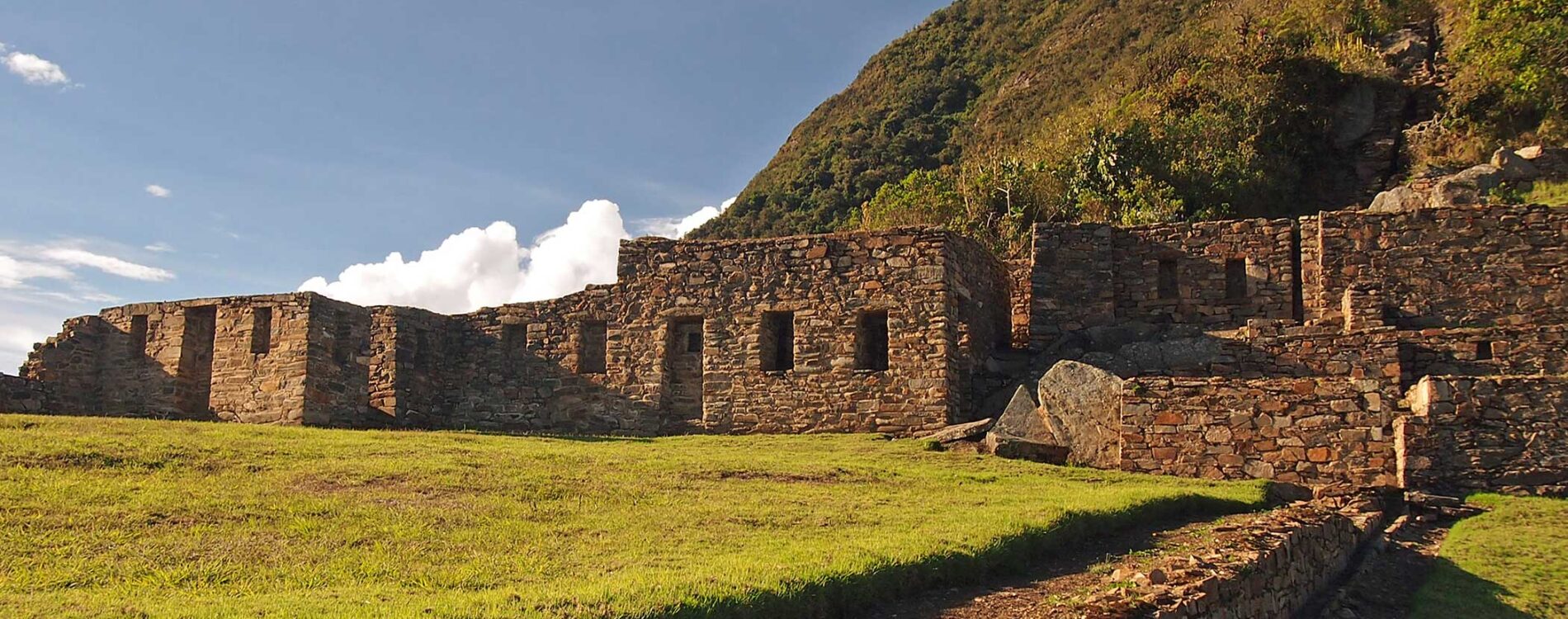
The architectural ingenuity of Choquequirao is a testament to the advanced engineering skills and spiritual depth of the Inca civilization. The site spans approximately 1,800 hectares and is divided into multiple sectors, each serving distinct functions. Visitors can marvel at the impeccably constructed terraces, ceremonial plazas, and residential areas, all connected by an intricate network of stairways and pathways. The Incas’ reverence for their environment is evident in the harmonious integration of the structures with the natural landscape, showcasing their profound understanding of sustainable living.
Choquequirao’s historical significance extends beyond its architectural marvels. It is believed to have been one of the last strongholds of the Inca resistance against Spanish conquest. The site served as a refuge for the Incas fleeing the Spanish invaders, and its remote location provided a strategic advantage. The legacy of Choquequirao as a symbol of Inca resilience and cultural preservation endures to this day, offering visitors a deeper appreciation of the rich tapestry of history woven into its stones and pathways.
Choquequirao and Machu Picchu, two of Peru’s most iconic archaeological sites, often invite comparisons due to their shared Inca heritage and breathtaking settings. However, each site offers a distinct experience, making both worth exploring. While Machu Picchu is renowned worldwide and attracts over a million visitors annually, Choquequirao remains relatively off the beaten path, offering a more intimate, unspoiled encounter with Inca history.
Machu Picchu, often referred to as the “Lost City of the Incas,” boasts an impressive array of temples, palaces, and terraces perched high in the Andes. Its accessibility via train and a short hike makes it a popular destination for tourists of all ages and fitness levels. The site’s iconic status and ease of access have led to significant visitor traffic, which, while managed through regulations, can still detract from the tranquility and sense of discovery that one might seek.
In contrast, Choquequirao offers a more challenging and rewarding adventure. The journey to this hidden gem involves a rigorous trek that spans multiple days, traversing steep mountain trails and lush valleys. This demanding route deters casual tourists, ensuring that those who make the pilgrimage are rewarded with solitude and unparalleled vistas. Choquequirao’s extensive terraces, ceremonial platforms, and intricate stonework rival those of Machu Picchu, yet the experience is often described as more serene and contemplative.
Ultimately, the choice between Choquequirao and Machu Picchu depends on the type of adventure one seeks. Machu Picchu’s grandeur and accessibility make it an ideal starting point for those new to Inca history. At the same time, Choquequirao’s remote allure offers a deeper connection with the past and a sense of accomplishment for seasoned trekkers. Together, these sites complement each other, painting a fuller picture of the Inca civilization’s architectural and cultural achievements.
Embarking on a journey to Choquequirao is an adventure in itself, requiring careful planning and a spirit of exploration. The trek to this hidden treasure typically begins in the town of Cachora, approximately 160 kilometers from Cusco. From Cusco, travelers can take a bus or arrange private transportation to Cachora, the gateway to the Choquequirao trek. The journey to Cachora offers a glimpse into the diverse landscapes of the Andean region, setting the stage for the adventure ahead.
The trek from Cachora to Choquequirao spans around 30 kilometers and usually takes three to four days to complete. The trail is well-marked but challenging, with steep ascents and descents that test even experienced hikers. The first leg of the journey involves a descent into the Apurímac River valley, followed by a strenuous climb up to the Marampata village, which serves as a standard campsite for trekkers. The breathtaking views of the surrounding mountains and the roar of the Apurímac River below make the effort worthwhile.
As trekkers approach Choquequirao, the landscape transitions from arid valleys to lush cloud forests, teeming with diverse flora and fauna. The final ascent to the archaeological site is a rewarding experience, with the ancient terraces and structures gradually revealing themselves through the mist. Upon arrival, visitors are often struck by the sheer scale and beauty of Choquequirao, a testament to the Incas’ ingenuity and reverence for their surroundings. The journey to Choquequirao is not just a physical challenge but a transformative experience that deepens one’s appreciation for Peru’s natural and cultural heritage.
Timing your visit to Choquequirao is crucial to ensure a safe and enjoyable experience, as the Andean climate can be unpredictable. The best time to embark on the trek is during the dry season, which runs from April to October. During these months, the weather is relatively stable, with clear skies and minimal rainfall, providing ideal conditions for hiking and exploring the archaeological site. The dry season also offers the best visibility, allowing trekkers to fully appreciate the panoramic views of the surrounding mountains and valleys.
While the dry season is the most popular time to visit, it is essential to be prepared for varying temperatures. Mornings and evenings can be pretty chilly, especially at higher altitudes, so layering clothing is advisable. Daytime temperatures, on the other hand, can be warm and pleasant, making trekking comfortable. The dry season’s favorable weather conditions also mean that the trails are less muddy and more navigable, reducing the risk of slips and falls.
Visiting Choquequirao during the rainy season, from November to March, presents a different set of challenges and rewards. The trails can become muddy and slippery, making the trek more difficult and potentially hazardous. However, the rainy season also brings lush, vibrant landscapes and fewer tourists, offering a more secluded and intimate experience. For those who are well-prepared and seeking solitude, the rainy season can be a unique opportunity to witness Choquequirao in its verdant, mist-shrouded glory.
Trekking to Choquequirao offers a variety of options and itineraries, catering to different levels of fitness and adventure. The classic Choquequirao trek typically takes four days and three nights, starting from Cachora and culminating in the exploration of the archaeological site. This itinerary allows for a paced journey, with ample time to acclimatize and appreciate the diverse landscapes along the way. The trek involves camping at designated sites, such as Chiquisca and Marampata, where trekkers can rest and replenish before continuing their ascent.
For those seeking a more extended adventure, the Choquequirao to Machu Picchu trek offers an unparalleled journey through the heart of the Andean wilderness. This trek can take between eight and twelve days, depending on the chosen route and pace. The extended trek connects two of Peru’s most iconic archaeological sites, providing a comprehensive exploration of Inca history and culture. Along the way, trekkers will encounter remote villages, pristine landscapes, and lesser-known ruins, adding depth and richness to the experience.
Guided treks are a popular option for those who prefer structured itineraries and additional support. Professional guides provide valuable insights into the history and significance of the sites, as well as logistical assistance with navigation, camp setup, and meal preparation. Guided treks also offer the advantage of mule support, reducing the physical burden on trekkers and allowing them to focus on the journey. Whether choosing a guided or self-supported trek, it is essential to plan and prepare thoroughly, ensuring that all necessary gear, permits, and provisions are in place for a safe and rewarding adventure.
Choquequirao is not only an archaeological treasure but also a haven for biodiversity, boasting a rich array of flora and fauna. The site’s location in the transition zone between the Andean highlands and the Amazon rainforest creates a unique ecosystem that supports a diverse range of species. As trekkers make their way to Choquequirao, they traverse through various ecological zones, each with its distinct vegetation and wildlife.
The lower elevations of the trek are characterized by arid valleys and dry forests, where hardy plants such as cacti, agaves, and shrubs thrive. As the trail ascends, the landscape transforms into lush cloud forests, home to towering trees draped in moss and orchids. These forests are teeming with birdlife, including colorful species such as hummingbirds, tanagers, and the Andean cock-of-the-rock. The cloud forests also provide habitat for elusive mammals like spectacled bears and pumas, though sightings are rare and considered a special treat.
Higher up, near the archaeological site, the flora transitions to high-altitude grasslands and puna vegetation. Here, hardy plants like ichu grass and alpine flowers thrive in harsh conditions, creating a stark yet beautiful landscape. The diverse plant life supports a variety of insects and small mammals, contributing to the overall ecological balance. The biodiversity of Choquequirao is a testament to the region’s environmental richness, offering visitors a deeper connection with nature and an appreciation for the delicate interplay between the environment and human history.
Visiting Choquequirao is not just about exploring ancient ruins and breathtaking landscapes; it is also an opportunity to engage with the local communities that call the Andean region home. The villages and towns along the trekking route offer a glimpse into the traditional lifestyles and cultural heritage of the Quechua-speaking people. Interacting with these communities provides valuable insights into their customs, traditions, and daily life, enriching the overall travel experience.
In villages like Cachora and Marampata, visitors can observe traditional agricultural practices, including the cultivation of crops such as maize, potatoes, and quinoa using age-old techniques. The terraces that dot the landscape are a testament to the ingenuity of the local farmers, who have adapted to the challenging terrain and created sustainable agricultural systems. Engaging with locals offers an opportunity to learn about their connection to the land and how they preserve their cultural heritage.
Cultural exchanges often extend to the sharing of traditional music, dance, and cuisine. Visitors may have the chance to participate in festivities, witness traditional dances, and sample local delicacies such as pachamanca (a traditional Peruvian dish cooked in an underground oven) and chicha (a fermented corn beverage). These experiences provide a deeper understanding of the region’s cultural fabric and foster a sense of connection and respect between travelers and local communities.
Supporting local initiatives and responsible tourism practices is essential to preserving Choquequirao’s cultural and natural heritage. Travelers are encouraged to engage with community-based tourism projects that provide economic benefits to local communities and promote sustainable development. By choosing to interact respectfully and support local initiatives, visitors help preserve the cultural richness and ecological integrity of this remarkable region.
Visiting Choquequirao requires careful planning and preparation to ensure a safe and enjoyable experience. Here are some essential tips to help you make the most of your adventure:
By following these tips and approaching your visit with a spirit of adventure and respect, you can ensure a memorable and rewarding experience at Choquequirao.
Choquequirao stands as a testament to the ingenuity, resilience, and spiritual depth of the Inca civilization. Its remote location, awe-inspiring architecture, and breathtaking natural surroundings make it a destination that offers a unique and profound travel experience. Unlike the more frequented Machu Picchu, Choquequirao offers an opportunity to explore an ancient wonder without the crowds, fostering a more intimate and contemplative connection with the past.
The journey to Choquequirao is an adventure that challenges both body and spirit, rewarding trekkers with unparalleled vistas, diverse ecosystems, and the chance to engage with local cultures. The site’s historical significance as a refuge for the Inca resistance and its role in preserving Inca heritage add depth and context to the exploration, enriching the overall experience.
Whether you are an avid hiker, a history enthusiast, or a nature lover, Choquequirao offers something for everyone. Its blend of cultural, historical, and natural wonders creates a holistic travel experience that transcends the ordinary. By choosing to visit Choquequirao, you are not only embarking on a remarkable adventure but also contributing to the preservation and appreciation of one of Peru’s most cherished treasures.
As you plan your travels and seek destinations that offer meaningful and transformative experiences, consider adding Choquequirao to your bucket list. This hidden gem of Peru provides an unforgettable journey that leaves you with lasting memories and a deeper appreciation for the rich tapestry of history and nature that defines this extraordinary region.
Unlike Machu Picchu, where you can reach by train and climb on buses, Choquequirao is a destination acquired through intense sacrifice and effort. They are strenuous walks that involve descents and steep slopes with little oxygen—the way there is mostly walking and camping. Your water supply may be insufficient; you pass out at high altitudes or burn while walking under the intense Andean sun. What can make the trip take 4 to 5 days, unless you visit nearby villages or do it quickly?
From the village of Cachora to Choquequirao, we walk about 31 kilometers without including the route through the ruins. The return would be the same distance (62 km in total). A large part of the route involves descending a large mountain, while the other half requires climbing.
The Citadel is at 3,035 m, and the lowest point of the walk will be at 1,461 m. The climate resembles Cusco’s, adjusting to the heights before the trek.
The Road to Choquequirao:
The road to Choquequirao consists of two distinct mountains. The initial stretch leads to the viewpoint of Capuliyoc; then, the whole route is a great descent, sometimes dodging, and finally connects with a remarkable ascent of 1500 meters of unevenness.
As stated above, the road is hard; luckily, everyone can travel at their own pace. There are several camps, so it is unnecessary to say where to stop or walk by day. It is estimated that there is a camp every 3 hours.
The most popular stopping points on the Apurimac side are
And from the other side (Cusco)
On the way, several camps run by villagers have begun catering to visitors. If you do not bring a tent, you rent one, and campsites are available every three hours of hiking. There, they have bathrooms and common areas for cooking.
Again, it is a hard road of significant ascents and great descents. A reasonable average to arrive is four nights / five days. In ideal conditions, of optimum physical condition and experience, it would be possible to do it in 3 days / 4noches more or less like this:
Trekking details to Choquequirao:
The blocker is imperative and repellent. It would not come with any more glasses, something to cover the head, and your camping equipment (lantern, tent, cooking utensils, medicines, cleansing tablets, rainponcho, ventilated clothes, and coat).
Trekking poles:
It is highly recommended for steep descents and climbs. They will also help you take long walks and get less tired.
Suitable footwear for the walk.
Good boots and socks are essential for backpackers. To learn more about footwear, watch this video and read this article on choosing suitable footwear.
If this road seems very hard, another option is to take a 5.4-kilometer cable car from Huañipaca to Choquequirao. It plans to cross the Apurimac River in 15 minutes. The cable car will come specifically from the town of Kiuñalla, carrying 50 passengers per cabin or 400 per hour.
Thanks for reading this article. If you like, please use the social links at the end to share them. Have a great trip!